


Les Granges par la Chailleuse

drarep
User
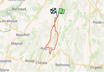

Length
17.8 km

Max alt
559 m

Uphill gradient
408 m
Km-Effort
23 km

Min alt
446 m

Downhill gradient
408 m
Boucle
Yes
Creation date :
2019-12-22 09:13:24.254
Updated on :
2019-12-22 09:20:42.783
4h58
Difficulty : Medium

FREE GPS app for hiking
 SityTrail
IGN / Geographical institutes
SityTrail Plus
The world is yours!
About
Trail Walking of 17.8 km to be discovered at Bourgogne-Franche-Comté, Jura, La Chailleuse. This trail is proposed by drarep.
Positioning
Country:
France
Region :
Bourgogne-Franche-Comté
Department/Province :
Jura
Municipality :
La Chailleuse
Location:
Saint-Laurent-la-Roche
Start:(Dec)
Start:(UTM)
692925 ; 5164031 (31T) N.
Comments